:quality(70)/cloudfront-us-east-1.images.arcpublishing.com/cmg/JIFG55NSN5HKZK6LKEZ4C7UU5I.jpg)
Jacksonville, Fl. — The “Buresh Bottom Line”: Always be prepared!.....First Alert Hurricane Preparation Guide... City of Jacksonville Preparedness Guide... Georgia Hurricane Guide.
STAY INFORMED: Get the * FREE * First Alert Weather app
FREE NEWS UPDATES, ALERTS: Action News Jax app for Apple | For Android
WATCH “Preparing for the Storm”
WATCH “The Ins & Outs of Hurricane Season”
READ the First Alert Hurricane Center “Preparation Guide”
***** ALWAYS CHECK & RE-CHECK THE LATEST FORECAST & UPDATES! *****
REMEMBER WHEN A TROPICAL STORM OR HURRICANE IS APPROACHING: Taping windows is *not* recommended & will not keep glass from breaking. Instead close curtains & blinds.
Realize the forecast cone (”cone of uncertainty”) is the average forecast error over a given time - out to 5 days - & *does not* indicate the width of the storm &/or where damage might occur.

*** LOCAL (Jacksonville/NE Fl./SE Ga.) IMPACTS FROM THE TROPICS: None through Tue. Some showers from nearby disturbance + enhanced onshore winds resulting in rough seas & a heightened rip current risk by late Wed. - Thu. into Fri.
The Atlantic Basin Overview:
(1) an upper level trough is over the Central/SW Atlantic is leaving behind a “piece” of the trough which will slowly move northwest this week. Initially this feature will be upper level & nontropical. Most forecast models have now come into agreement that surface development will be hard to come by given a good deal of dry air & moderate to strong wind shear. So it continues to look like a surface trough of low pressure arriving at Southeast U.S. coast anywhere from the Carolina’s to Florida by Friday enhancing bands of heavy showers, gusty onshore winds & a resultant high rip current risk at the beaches.
“Buresh Bottom Line”: there will be an uptick - a much needed one - in rainfall for NE Fl./SE Ga. through late this week though amounts don’t look to be all that great for most areas. Any surface/tropical development with this system should be gradual & weak & will be something to keep an eye on though this looks to stay pretty weak overall. There will be gusty onshore flow resulting in rough seas/surf & an increasing rip current risk at area beaches. Swim & surf with a buddy & as close to a lifeguard as at all possible.
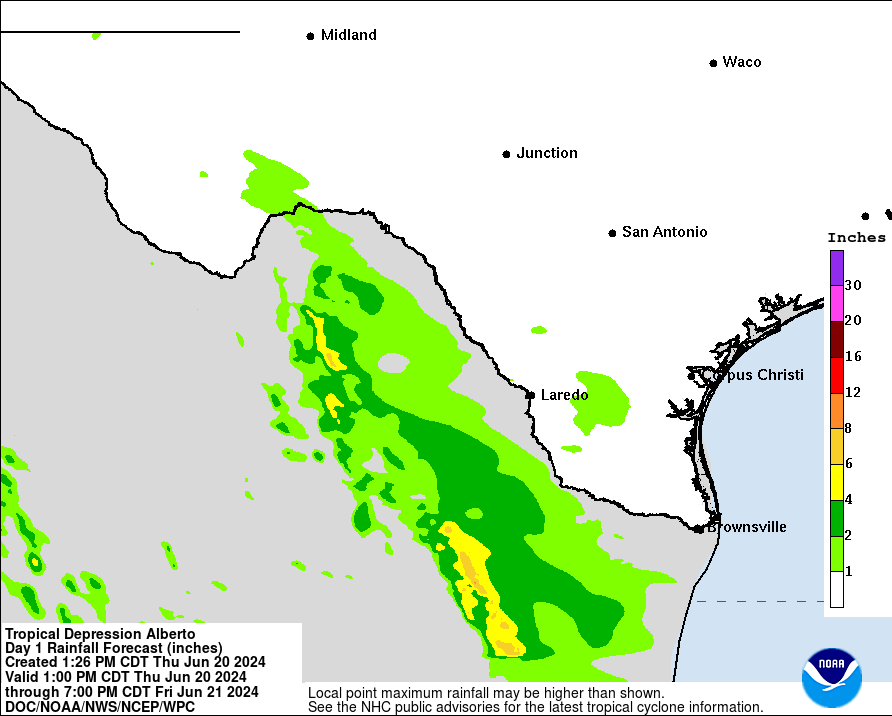
(2) A Tropical Storm WARNING: the Texas coast from Port O’Connor southward to the mouth of the Rio Grande ... the northeastern coast of Mexico south of the mouth of the Rio Grande to Puerto de Altamira.
Broad low pressure has developed over the Bay of Campeche & will slowly drifting to the west/northwest. This low could become the first named storm of the season for the Atlantic Basin - “Alberto”. The most significant impacts are likely to be very heavy rain & flooding for Mexico extending northward into South Texas where rainfall may exceed 10″ through the upcoming week though this is also an area suffering from drought so a certain amount of the rain will be welcome.
Bottom line: no local impacts from the Gulf disturbance for Jacksonville or any of Florida. But there will be a significant heavy rain set-up for much of South Texas.
(3) A third area of low pressure may develop over the weekend into the following week over the Southern & Western Gulf of Mexico. With upper level high pressure remaining across the Central & Eastern U.S., this low - if it develops - would most likely stay over the Central or Western Gulf though still early on this possible system.


The upper oceanic heat content (UOHC) [tropical cyclone heat potential/TCHP] across the SW Atlantic, Gulf & Caribbean is unseasonably high for this time of year:


Water vapor loop (dark blue/yellow is dry mid & upper level air):


June tropical cyclone origins (early season breeding grounds are the Gulf &/or Western Caribbean:

Averages below based on climatology for the Atlantic Basin for November (7 hurricanes so far, 19 tropical storms):
Wind shear (red - strong shear; green - low shear):


Saharan dust spreads west each year from Africa driven by the prevailing winds (from east to west over the Atlantic). Dry air = yellow/orange/red/pink. Widespread dust is indicative of dry air that *can* interfere with the development of tropical cyclones. However, sometimes “wanna’ be” waves will just wait until they get to the other side of - or away from - the dust plume then try to develop if other conditions are favorable. In my personal opinion, there is way too much “hoopla” about the presence of Saharan dust & how it relates to tropical cyclones. In any case, the peak of Saharan dust typically is in June & July.

2024 names..... “Alberto” is the first name on the Atlantic list (names are picked at random by the World Meteorological Organization... repeat every 6 years). Historic storms are retired [Florence & Michael in ’18 (the last time this year’s list was used)... Dorian in ’19 & Laura, Eta & Iota in ‘20, Ida in ‘21 & Fiona & Ian in ‘22]). In fact, this year’s list of names is rather infamous because of the ‘04 season when Charley, Frances, Jeanne & Ivan - all retired names - hit Florida within a matter of about 6 weeks. The WMO decided - beginning in 2021 - that the Greek alphabet will be no longer used & instead there will be a supplemental list of names if the first list is exhausted (has only happened three times - 2005, 2020 & 2021). The naming of tropical cyclones began on a consistent basis in 1953. More on the history of naming tropical cyclones * here *.


East Atlantic:


Mid & upper level wind shear (enemy of tropical cyclones) analysis (CIMMS). The red lines indicate strong shear:

Water vapor imagery (dark blue indicates dry air):

Deep oceanic heat content over the Gulf, Caribbean & deep tropical Atlantic. The colors will brighten greatly as the water warms to greater depths deeper into the season:

Sea surface temp. anomalies:


SE U.S. surface map:

Surface analysis centered on the tropical Atlantic:

Surface analysis of the Gulf:

Caribbean:

Atlantic Basin wave period forecast for 24, 48, 72 & 96 hours respectively:


East & Central Pacific:


West Pacific:

Global tropical activity:


Cox Media Group
:quality(70)/cloudfront-us-east-1.images.arcpublishing.com/cmg/SKX4RKW645ERTATCLA4V2FVRKQ.png)
:quality(70)/cloudfront-us-east-1.images.arcpublishing.com/cmg/VFGNOWDMQRFUNDZYHRTIPEQYYQ.jpg)
:quality(70)/cloudfront-us-east-1.images.arcpublishing.com/cmg/SHM5VKGXUVFSNEJL6Z5QFC5VQY.jpg)
:quality(70)/cloudfront-us-east-1.images.arcpublishing.com/cmg/SCWUKX27NRFXVFR2KCQYQ3ZPQY.jpg)
:quality(70)/cloudfront-us-east-1.images.arcpublishing.com/cmg/LMWXGO6SNBH6FA3USYDZX4MVCA.jpg)
:quality(70)/cloudfront-us-east-1.images.arcpublishing.com/cmg/IOTS67DKL4EVA2UQ7LCRVUSIOQ.jpg)
:quality(70)/cloudfront-us-east-1.images.arcpublishing.com/cmg/MO5DVOIODGGOHASRWRVK45ZGAU.jpg)
 Sign Up

