:quality(70)/cloudfront-us-east-1.images.arcpublishing.com/cmg/JIFG55NSN5HKZK6LKEZ4C7UU5I.jpg)
Jacksonville, Fl. — The “Buresh Bottom Line”: Always be prepared!.....First Alert Hurricane Preparation Guide... City of Jacksonville Preparedness Guide... Georgia Hurricane Guide.
STAY INFORMED: Get the * FREE * First Alert Weather app
FREE NEWS UPDATES, ALERTS: Action News Jax app for Apple | For Android
WATCH “Preparing for the Storm”
WATCH “The Ins & Outs of Hurricane Season”
READ the First Alert Hurricane Center “Preparation Guide”
***** ALWAYS CHECK & RE-CHECK THE LATEST FORECAST & UPDATES! ****
Tropics threats for Jacksonville/NE Florida/SE Georgia: No direct impacts from tropical systems *but* onshore flow has increased again with rough seas & surf = a high rip current risk through the week. The heavy rainfall threat remains throughout the week with some possible extra tropical moisture courtesy distant Francine to the west.
“Buresh Bottom Line”:
* “Francine” over the Western Gulf of Mexico with direct impacts to Texas & especially Louisiana & Mississippi centered on Wed. through Thu. but at least some storm surge to Mobile & Pensacola seems likely. Heavy rain & a threat for tornadoes will extend well inland in Louisiana, Mississippi & Alabama as far north as Arkansas & Tennessee & as far east as the Florida Panhandle.
* A couple of tropical waves over the Central & Eastern Atlantic may develop but look to stay far out to sea for the time being.
* Some “in-close” development will be possible over the next week to 10 days near or along the U.S. east coast. Especially watched the Carolina coast to the Mid-Atlantic early to middle part of next week.
The Atlantic Basin Overview:
A Storm Surge WARNING: High Island Texas to the Mississippi/Alabama Border ... Vermilion Bay ... Lake Maurepas ... Lake Pontchartrain
A Hurricane WARNING: The Louisiana coast from Sabine Pass eastward to Grand Isle
A Storm Surge WATCH: Mississippi/Alabama Border to the Alabama/Florida Border ... Mobile Bay
A Tropical Storm WARNING: Texas coast - High Island to Sabine Pass ... East of Grand Isle Louisiana to the Mississippi/Alabama border, including metropolitan New Orleans ... Lake Pontchartrain ... Lake Maurepas
A Tropical Storm WATCH: Texas coast from Matagorda to High Island ... The Alabama coast from the Mississippi/Alabama border to the Alabama/Florida border.
(1) ‘91-L′ - “Potential Tropical Cyclone Six” was upgraded to “Francine” Mon. morning. Francine is a product of the Caribbean wave I’ve been tracking for the past 7+ days reached the Yucatan Peninsula Friday & moved over the Bay of Campeche over the weekend. Meanwhile... weak surface low pressure near the coast of Texas drifted southward. As hypothesized late last week, it appears these two are interacting & will develop a tropical cyclone over the far Western Gulf of Mexico. Forecast models have nicely converged on track & intensity with the European & Climavision ‘Horizon’ models joining the GFS & Canadian with a hurricane moving inland over Louisiana Wed/Wed. night. The GFS continues to be more east with a landfall closer to New Orleans Wed. evening... Climavision is more west but trending east... & the European & Canadian models are on Central Louisiana coast but also slowly trending east. Weak to moderate upper level troughing persists over the Central & Eastern U.S. It looks like there will be enough of a “softness” extending all the way to the Northern Gulf to maintain the necessary alleyway to help move Francine more northeast by Wed. with an increase in forward speed before slowing while moving inland & weakening. Lower shear & warm ocean water point to a strengthening storm through Wed. morning before shear increases over the Northern Gulf & at landfall though by then it may not matter a whole lot as the system should be well developed + moving with - at least somewhat - the shear vectors in addition to upper air ventilation provided by the upper level trough.
Landfall Wed. afternoon/evening between Lake Charles & New Orleans approximately south & southeast of Lafayette. Folks all along the Gulf Coast - & especially from Texas to Louisiana & Mississippi - should stay up to date on the latest forecasts.
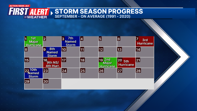
For the Atlantic: the sixth named - ‘F’ - storm of the season avg. date is Aug. 29th... the 4th hurricane avg. date is Sept. 16th.
(2) We’re also seeing mixed signals regarding a nearly stationary boundary from the Gulf to the Western Atlantic that gets reinforced by a series of upper level troughs & possible low pressure developing at the surface along the front all the way through next week. This could be some “in-close” development anywhere from the Gulf to the far Western Atlantic. Some models indicate the potential for some tropical activity from near Florida northward across the Western Atlantic next week, even as early late this weekend. A variety of model solutions are out there for low pressure early next week east & northeast of Florida with some models - the European & Climavison in particular - taking a potential tropical cyclone to the eastern seaboard anywhere from the Carolina’s to the Mid-Atlantic - something to keep a very close eye on.
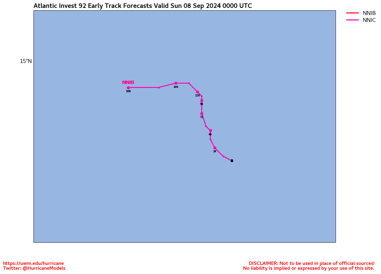
(3) Multiple tropical waves are moving west & northwest between the Caribbean & Africa - something one would expect this time of year. At least one - ‘92-L’ is losing its longer term potential in favor of a stronger tropical wave to its east. The Bermuda high remains displaced to the east & northeast over the Atlantic. Such a position favors an alleyway for systems to turn north over the Central Atlantic... at least over the next 1-2 weeks.
Fitting the pattern for the increased tropical activity - as well as the recent wet/cloudy spell for Florida - is persistent & seasonally strong surface high pressure at northern latitudes from the Central U.S. to the Northwest Atlantic. This high pressure will bring has brought an early taste of fall across the Northern U.S. & generally encourages low pressure to the south - a pattern that often favors tropical development at southern latitudes. It’s Mother Nature’s constant balancing/compensating act. And it’s likely why we’ve seen forecast models struggle with the overall pattern developing sometimes spurious & frequent low pressure areas near & south of about 35 degrees N.


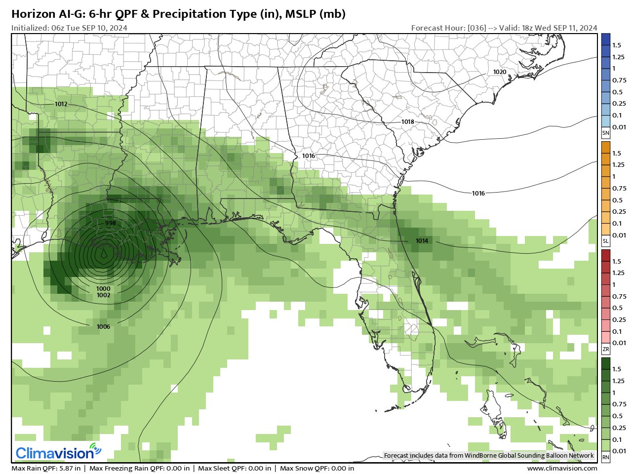
The experimental Climavision ‘Horizon’ model below for Wed. afternoon, Sept. 11th shows Francine on the Central Louisiana coast. The ‘horizon’ trend has been east & stronger:
From CIMSS - diagnosis below of shear shows strengthening values over the northern half of the Gulf which should help spread tropical moisture downwind all the way to Florida increasing the heavy rain potential. Forecast models continue to strengthen Francine right up to landfall despite the strong shear which may be due to the shear vectors oriented similarly to the forward movement of Francine + upper level diffluence. Though I wonder about how much the shear may disrupt Francine’s core.

Very heavy rain for much of the Gulf coast yet again for the upcoming week:


Climavision ‘horizon’ model for Sun., 09/15 afternoon showing developing low pressure - which could become tropical - over the SW Atlantic. Virtually all models show some kind of development but differ on where it goes with the GFS model farther east & little or no impact to the U.S. while the European takes the low to the Carolina coast & points north.


‘Velocity potential anomalies’ below shows massive “sinking” air (brown lines) & overall hostile conditions for tropical development continue across the Atlantic Basin. In such a state, tropical development can occur but overall conditions are not as conducive as when there is overall rising (green lines) air such as much of the Pacific Basin where convection is active. This “pulse” of upward motion is moving closer to the Atlantic Basin & is likely aiding the Western Gulf system & will be spreading eastward over the next couple of weeks.

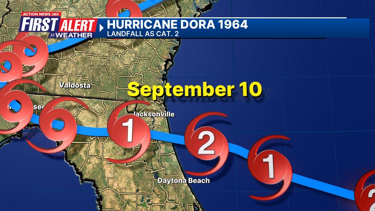
Historical Note: 60 years ago - Cat. 2 hurricane “Dora” made landfall in St. Johns Co. north of St. Augustine just after midnight Sept. 10, 1964. Then President Lyndon B. Johnson visited Jacksonville Beach declaring NE Fl. a national disaster area... while the Beatles still played in Jax. Florida Times-Union report & photos * here *. Dora is the last hurricane eye to make landfall on the Northeast Florida coast.
REMEMBER WHEN A TROPICAL STORM OR HURRICANE IS APPROACHING: Taping windows is *not* recommended & will not keep glass from breaking. Instead close curtains & blinds.
Realize the forecast cone (”cone of uncertainty”) is the average forecast error over a given time - out to 5 days - & *does not* indicate the width of the storm &/or where damage might occur.

The upper oceanic heat content (UOHC) [tropical cyclone heat potential/TCHP] across the SW Atlantic, Gulf & Caribbean is very high:


Water vapor loop (dark blue/yellow is dry mid & upper level air):


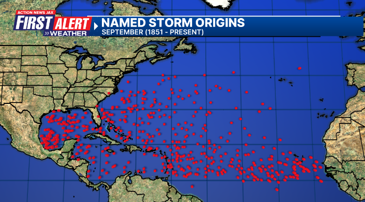
September tropical cyclone origins (early season breeding grounds are the Gulf &/or Western Caribbean:
Averages below based on climatology for the Atlantic Basin for September (2 hurricane so far, 3 tropical storms):
Wind shear (red - strong shear; green - low shear):


Saharan dust spreads west each year from Africa driven by the prevailing winds (from east to west over the Atlantic). Dry air = yellow/orange/red/pink. Widespread dust is indicative of dry air that *can* interfere with the development of tropical cyclones. However, sometimes “wanna’ be” waves will just wait until they get to the other side of - or away from - the dust plume then try to develop if other conditions are favorable (we’ve already seen this with Beryl & Debby this year). In my personal opinion, there is way too much “hoopla” about the presence of Saharan dust & how it relates to tropical cyclones. In any case, the peak of Saharan dust typically is in June & July.

2024 names..... “Francine” is the next name on the Atlantic list (names are picked at random by the World Meteorological Organization... repeat every 6 years). Historic storms are retired [Florence & Michael in ’18 (the last time this year’s list was used)... Dorian in ’19 & Laura, Eta & Iota in ‘20, Ida in ‘21 & Fiona & Ian in ‘22]). In fact, this year’s list of names is rather infamous because of the ‘04 season when Charley, Frances, Jeanne & Ivan - all retired names - hit Florida within a matter of about 6 weeks. The WMO decided - beginning in 2021 - that the Greek alphabet will be no longer used & instead there will be a supplemental list of names if the first list is exhausted (has only happened three times - 2005, 2020 & 2021). The naming of tropical cyclones began on a consistent basis in 1953. More on the history of naming tropical cyclones * here *.


East Atlantic:


Mid & upper level wind shear (enemy of tropical cyclones) analysis (CIMMS). The red lines indicate strong shear:
Water vapor imagery (dark blue indicates dry air):

Deep oceanic heat content over the Gulf, Caribbean & deep tropical Atlantic. The colors will brighten greatly as the water warms to greater depths deeper into the season:

Sea surface temp. anomalies:


SE U.S. surface map:

Surface analysis centered on the tropical Atlantic:

Surface analysis of the Gulf:

Caribbean:

Atlantic Basin wave period forecast for 24, 48, 72 & 96 hours respectively:


East & Central Pacific:


Hawaii satellite imagery:


West Pacific:

Global tropical activity:


Cox Media Group
:quality(70)/cloudfront-us-east-1.images.arcpublishing.com/cmg/SMNDFCD6BBDXNAYEI7VSPW2P44.jpeg)
:quality(70)/cloudfront-us-east-1.images.arcpublishing.com/cmg/SKX4RKW645ERTATCLA4V2FVRKQ.png)
:quality(70)/cloudfront-us-east-1.images.arcpublishing.com/cmg/4TQDXERT5VGORNZ4NQWXNO5H64.png)
:quality(70)/cloudfront-us-east-1.images.arcpublishing.com/cmg/VFGNOWDMQRFUNDZYHRTIPEQYYQ.jpg)
:quality(70)/cloudfront-us-east-1.images.arcpublishing.com/cmg/V7JDMMD6JJEEHIL6C7OSLV3ABU.png)
:quality(70)/cloudfront-us-east-1.images.arcpublishing.com/cmg/5CA2ZO7DXNF5TNJEP4ENVDUBNY.jpg)
:quality(70)/cloudfront-us-east-1.images.arcpublishing.com/cmg/SQ3PKBWQUKJM4KRCZRTMDZ4V6I.jpg)
:quality(70)/cloudfront-us-east-1.images.arcpublishing.com/cmg/64B5ISMLYUPRXW7KIOO6BHNWLU.jpg)
 Sign Up

