:quality(70)/cloudfront-us-east-1.images.arcpublishing.com/cmg/JIFG55NSN5HKZK6LKEZ4C7UU5I.jpg)
Jacksonville, Fl. — The “Buresh Bottom Line”: Always be prepared!.....First Alert Hurricane Preparation Guide... City of Jacksonville Preparedness Guide... Georgia Hurricane Guide.
STAY INFORMED: Get the * FREE * First Alert Weather app
FREE NEWS UPDATES, ALERTS: Action News Jax app for Apple | For Android
WATCH “Preparing for the Storm”
WATCH “The Ins & Outs of Hurricane Season”
READ the First Alert Hurricane Center “Preparation Guide”
***** ALWAYS CHECK & RE-CHECK THE LATEST FORECAST & UPDATES! ****
Tropics threats for Jacksonville/NE Florida/SE Georgia: A high rip current risk at area beaches Fri. into the weekend due to distant Ernesto to the east.
The Atlantic Basin Overview:
(1) “Debby” - The 4th Atlantic named storm of the season strengthened into the 2nd hurricane of the season with the 11pm Sunday, 08/04 advisory. Debby was intensifying right up to landfall but thankfully ran out of time over the warm Gulf water with a 7am EDT - Mon., 08/05 - landfall at Steinhatchee some 60-70 miles north/northwest of Cedar Key followed by a second landfall as a tropical storm at Bulls Bay, SC early Thu.
For the details & summary on “Debby” - click * here * (”Buresh Blog”).
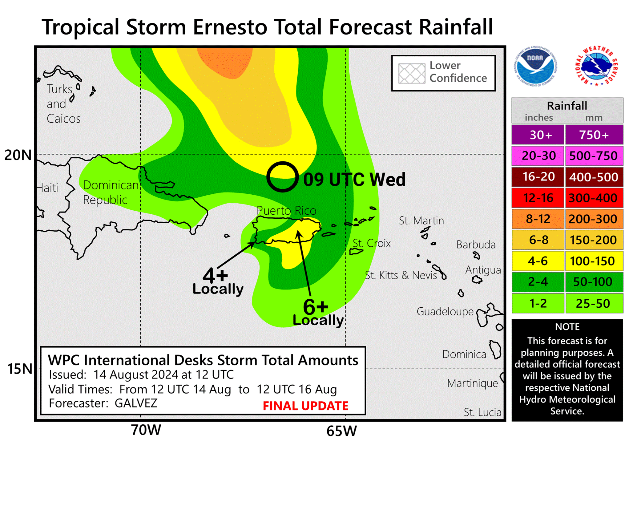
(2) A Hurricane WATCH: U.S. Virgin Islands ... British Virgin Islands ... Vieques and Culebra. A Tropical Storm WARNING: St. Kitts, Nevis, Montserrat, Antigua, Barbuda, and Anguilla ... Guadeloupe ... St. Martin and St. Barthelemy ... Sint Maarten ... British Virgin Islands ... U.S. Virgin Islands ... Puerto Rico ... Vieques and Culebra
Disturbance - ‘98-L’ (’potential tropical cyclone five’) came off the coast of Africa early to mid last week & was upgraded Mon. afternoon to tropical storm “Ernesto” - the 5th named storm of the Atlantic season (avg. date for the 5th storm is Aug. 22). The tropical cyclone will veer west/northwest upon approach to the Northeast Caribbean Sea. The broad circulation has a number of banding features plus indications of developing outflow overhead. Until a core develops with a decent concentration of convection, we may see jumps in where the system’s “center” is in addition to some erratic overall movement. Once better developed, the track becomes more straight forward over the next 5 days or so.
Virtually all forecast models show a hurricane eventually developing but when exactly will be huge for potential impacts on Puerto Rico & the Northern Lesser Antilles as well as the anticipated & forecast turn to the north. It looks like the center of Ernesto will past a little northeast & north of Puerto Rico which will lessen impacts *some* for Puerto Rico. But remember the mantra “No Such Thing as Just A”.... as in just a tropical storm. Heavy rain, flooding, strong winds & dangerous seas & surf will batter the Northern Windward Islands & Puerto Rico & nearby islands through Wed./early Thu. “Ernesto” is becoming strong enough/deep enough to feel the tug of an upper level trough to the north. The GFS is a little more south & west vs. other modeling through Puerto Rico. Then virtually all the global models latch on to a sharp northward turn east of the Bahamas & far to the east of Florida.
A pretty stout (for late Aug.) upper level trough will dig into the Eastern U.S. & far West Atlantic through the upcoming weekend. This trough & resultant alleyway will be key in the sharp turn to the north which will keep the future tropical cyclone well east of Florida & *possibly* the entire U.S. east coast. But we will have to watch the longer term for a possible stall once the deep Eastern U.S. trough lifts out depending on whether or not the trough fully picks up “Ernesto”. Indications are it will take a follow-up trough to fully capture Ernesto next week. This subsequent trough may very well draw Ernesto back to the north or even north/northwest for a while over the Northwest Atlantic with a threat to Bermuda by the upcoming weekend.
While forecast models have come into good agreement for the moment... the interaction with the upper troughs in the longer range - once north of Florida’s latitude - is not necessarily cut & dry & will probably be at least somewhat complicated in the end.
So it looks like a displacement in the Bermuda High over the Atlantic to the east + the seasonally strong trough near the U.S. east coast should allow for the necessary alleyway to keep this tropical cyclone well east of Florida late in the week/next weekend reaching approximately Jacksonville, Florida’s latitude (~30 degrees N) Friday but thousands of miles to the east. There will be, however, a serious rip current risk at area beaches with an easterly swell. It looks like the system will briefly stair step north over the West Atlantic early next week before turning more northeast again & this is the portion of the track forecast that could bring Nova Scotia or Newfoundland into “play” next week. Stay up to date on the latest forecasts!
Everyone & anyone living in or traveling to the Caribbean, the Bahamas, Bermuda & along the U.S. east coast - pay attention to what will soon be “Ernesto”.


Reminder: the shaded area below shows where tropical development is likely but is *not* a forecast cone:


Puerto Rico N.W.S. radar imagery:

The 500mb (~30,000 feet) forecast through the weekend showing the seasonally strong upper level trough that looks to “protect” Florida form Ernesto:


(3) A couple of tropical waves have moved off the coast of Africa & may have some long term potential to slowly develop while moving relatively slowly (vs. Ernesto) westward across the Eastern & Central Atlantic. Right now most forecast models show little development.
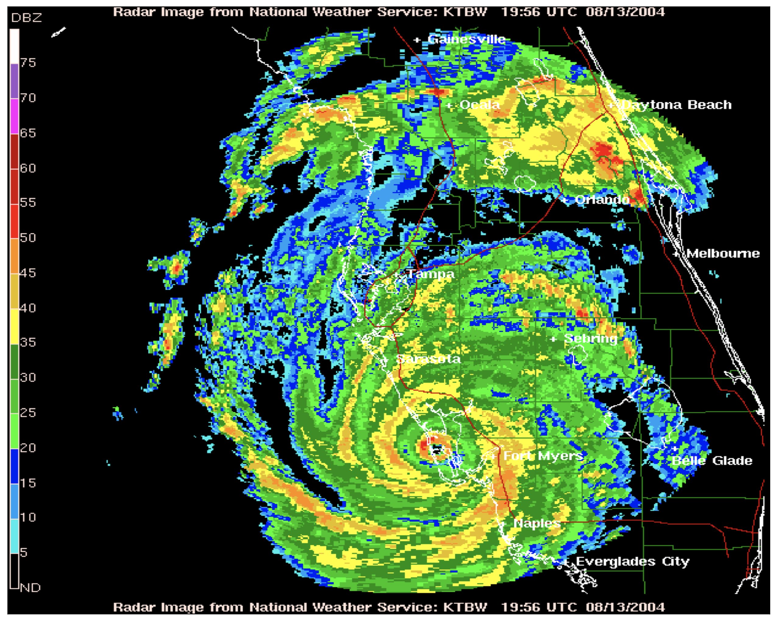
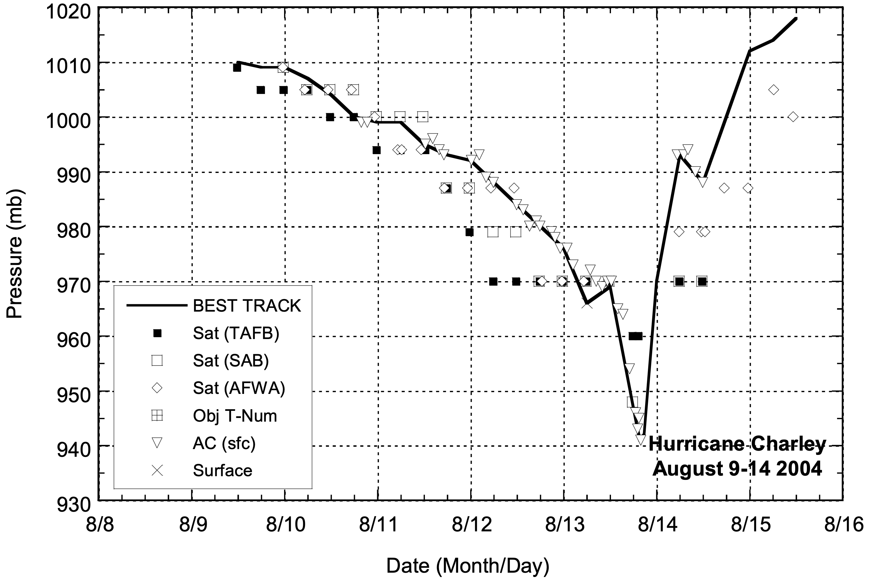
Historical note: Small but powerful Cat. 4 hurricane “Charley” made landfall 20 years ago - on Aug. 13th - on Florida’s southwest coast near Punta Gorda. This was the first Florida “major” hurricane landfall since “Andrew” (Cat. 5) in 1992 & Charley moved swiftly northeast across Florida causing extensive damage in Orlando as the eye wall was still intact. This very damaging scenario for Central Florida - winds measured greater than 100 mph - was the birth of the ‘extreme wind warning’. The N.W.S Charley post storm assessment * here *... Miami post storm report * here *... NHC tropical cyclone report * here *.

REMEMBER WHEN A TROPICAL STORM OR HURRICANE IS APPROACHING: Taping windows is *not* recommended & will not keep glass from breaking. Instead close curtains & blinds.
Realize the forecast cone (”cone of uncertainty”) is the average forecast error over a given time - out to 5 days - & *does not* indicate the width of the storm &/or where damage might occur.

The upper oceanic heat content (UOHC) [tropical cyclone heat potential/TCHP] across the SW Atlantic, Gulf & Caribbean is unseasonably high for this time of year:


Water vapor loop (dark blue/yellow is dry mid & upper level air):


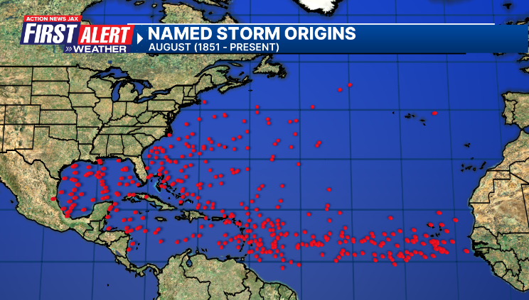
August tropical cyclone origins (early season breeding grounds are the Gulf &/or Western Caribbean:
Averages below based on climatology for the Atlantic Basin for August (1 hurricane so far, 3 tropical storms):

Wind shear (red - strong shear; green - low shear):


Saharan dust spreads west each year from Africa driven by the prevailing winds (from east to west over the Atlantic). Dry air = yellow/orange/red/pink. Widespread dust is indicative of dry air that *can* interfere with the development of tropical cyclones. However, sometimes “wanna’ be” waves will just wait until they get to the other side of - or away from - the dust plume then try to develop if other conditions are favorable (we’ve already seen this with Beryl & Debby this year). In my personal opinion, there is way too much “hoopla” about the presence of Saharan dust & how it relates to tropical cyclones. In any case, the peak of Saharan dust typically is in June & July.

2024 names..... “Francine” is the next name on the Atlantic list (names are picked at random by the World Meteorological Organization... repeat every 6 years). Historic storms are retired [Florence & Michael in ’18 (the last time this year’s list was used)... Dorian in ’19 & Laura, Eta & Iota in ‘20, Ida in ‘21 & Fiona & Ian in ‘22]). In fact, this year’s list of names is rather infamous because of the ‘04 season when Charley, Frances, Jeanne & Ivan - all retired names - hit Florida within a matter of about 6 weeks. The WMO decided - beginning in 2021 - that the Greek alphabet will be no longer used & instead there will be a supplemental list of names if the first list is exhausted (has only happened three times - 2005, 2020 & 2021). The naming of tropical cyclones began on a consistent basis in 1953. More on the history of naming tropical cyclones * here *.


East Atlantic:


Mid & upper level wind shear (enemy of tropical cyclones) analysis (CIMMS). The red lines indicate strong shear:

Water vapor imagery (dark blue indicates dry air):

Deep oceanic heat content over the Gulf, Caribbean & deep tropical Atlantic. The colors will brighten greatly as the water warms to greater depths deeper into the season:

Sea surface temp. anomalies:


SE U.S. surface map:

Surface analysis centered on the tropical Atlantic:

Surface analysis of the Gulf:

Caribbean:

Atlantic Basin wave period forecast for 24, 48, 72 & 96 hours respectively:


East & Central Pacific:


Hawaii satellite imagery:

West Pacific:

Global tropical activity:


“Ampil” is forecast to strengthen with potentially significant impacts on the east coast of Japan - including Tokyo - by Thu./Friday:


A weak “Son-Tinh” moves east of Japan this week:


Cox Media Group
:quality(70)/cloudfront-us-east-1.images.arcpublishing.com/cmg/SMNDFCD6BBDXNAYEI7VSPW2P44.jpeg)
:quality(70)/cloudfront-us-east-1.images.arcpublishing.com/cmg/SKX4RKW645ERTATCLA4V2FVRKQ.png)
:quality(70)/cloudfront-us-east-1.images.arcpublishing.com/cmg/4TQDXERT5VGORNZ4NQWXNO5H64.png)
:quality(70)/cloudfront-us-east-1.images.arcpublishing.com/cmg/VFGNOWDMQRFUNDZYHRTIPEQYYQ.jpg)
:quality(70)/cloudfront-us-east-1.images.arcpublishing.com/cmg/V7JDMMD6JJEEHIL6C7OSLV3ABU.png)
:quality(70)/cloudfront-us-east-1.images.arcpublishing.com/cmg/JZ6PJAXWC5BPK2FLASCIV3O4DY.jpg)
:quality(70)/cloudfront-us-east-1.images.arcpublishing.com/cmg/PR6EXXNJ6OOQK3BZJJUUW4WDWI.jpg)
:quality(70)/cloudfront-us-east-1.images.arcpublishing.com/cmg/ODDWBVWT43H6DBT6T5OMMGQYYQ.jpg)
:quality(70)/cloudfront-us-east-1.images.arcpublishing.com/cmg/JOPDZ7RLDCYRPHQYUWTGQCNRMM.jpg)
 Sign Up

