
Jacksonville, Fl. — The “Buresh Bottom Line”: Always be prepared!.....First Alert Hurricane Preparation Guide... City of Jacksonville Preparedness Guide... Georgia Hurricane Guide.
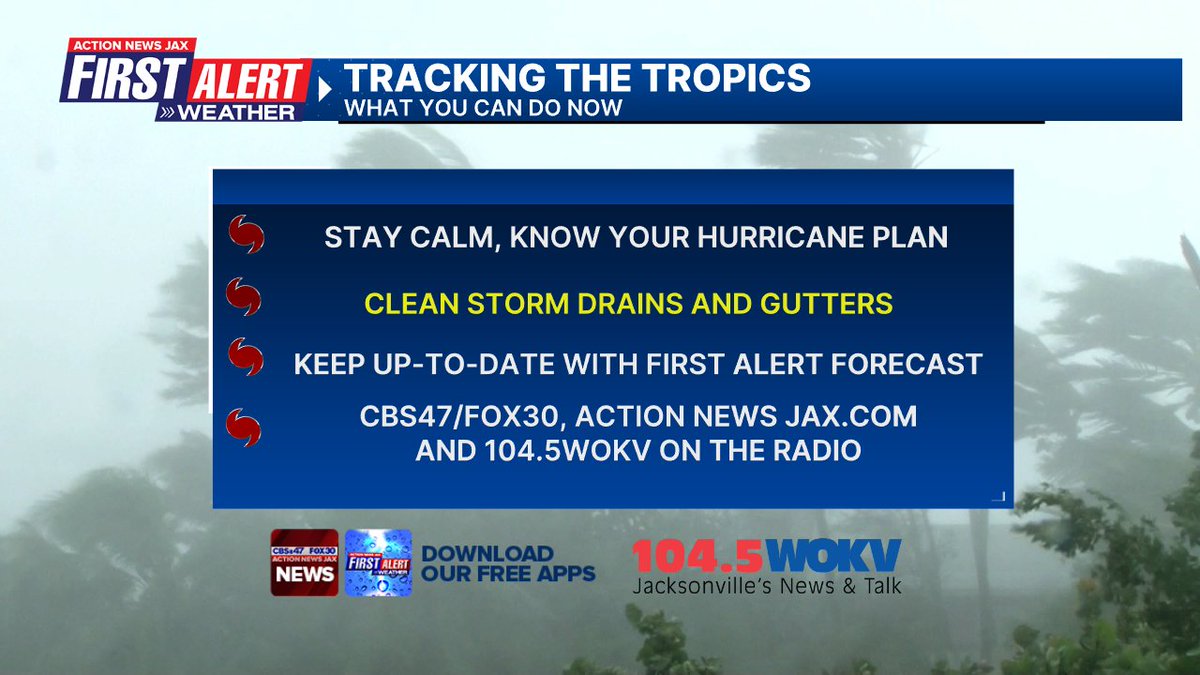
STAY INFORMED: Get the * FREE * First Alert Weather app
FREE NEWS UPDATES, ALERTS: Action News Jax app for Apple | For Android
WATCH “Preparing for the Storm”
WATCH “The Ins & Outs of Hurricane Season”
READ the First Alert Hurricane Center “Preparation Guide”
***** ALWAYS CHECK & RE-CHECK THE LATEST FORECAST & UPDATES! **** Heavy rain & flooding threat along with a few tornadoes & waterspouts... rough seas & surf, high rip current risk through at least Tuesday.
The “Buresh Bottom Line”:
* Debby will hit the Florida Big Bend with a Monday morning landfall - likely as a hurricane.
* Northeast Florida/Southeast Georgia concerns are centered around heavy rain - possibly very heavy, rough seas & surf, a high rip current risk & a few tornadoes/waterspouts. Winds should be gusty but not severe from Highway 301 to the beaches but will more significant & potentially damaging from Lake City to Waycross.
* Florida is the “fork in the road” for direction of movement & especially the forward speed.
* There is the potential for quite rapid strengthening upon approach to landfall.
* Heads up for all of Florida, the Eastern Gulf coast & the U.S. east coast.
* Gusty squalls of heavy rain & storms will impact Florida, Georgia & the coastal Carolina’s through midweek.
* A reminder that Jax/NE Fl./SE Ga. will be on the “messy” east side of the storm.
* Realize impacts from Debby will occur many miles from the center & OUTSIDE of the forecast cone.
* Forecasts are still in flux & subject to change
Specifics primarily for NE Fl./SE Ga. given *current* forecast track:
Rainfall: Severe flooding is legitimate concern. Amounts through Wed. will average 6-12″, locally more. As much as 10-15″ possibly nearing 2 feet is well within the realm of ‘possibility’ from Lake City to Waycross eastward across SE Ga. as Debby slows & possibly even stalls. A strong/steady wind from the south Monday may push water from the St. Johns River into parts of downtown Jacksonville. The more north & west over N. Fl & SE Ga., the heavier the rain.
Wind: sustained winds will average 20-30 mph with gusts 40-50 mph from Highway 301 to the coast though some higher speeds will be possible at/near the beaches due to less friction. Sustained winds may peak Monday at 50-60 mph with gusts 70+ mph from Lake City to Waycross due to the closer proximity to the center.
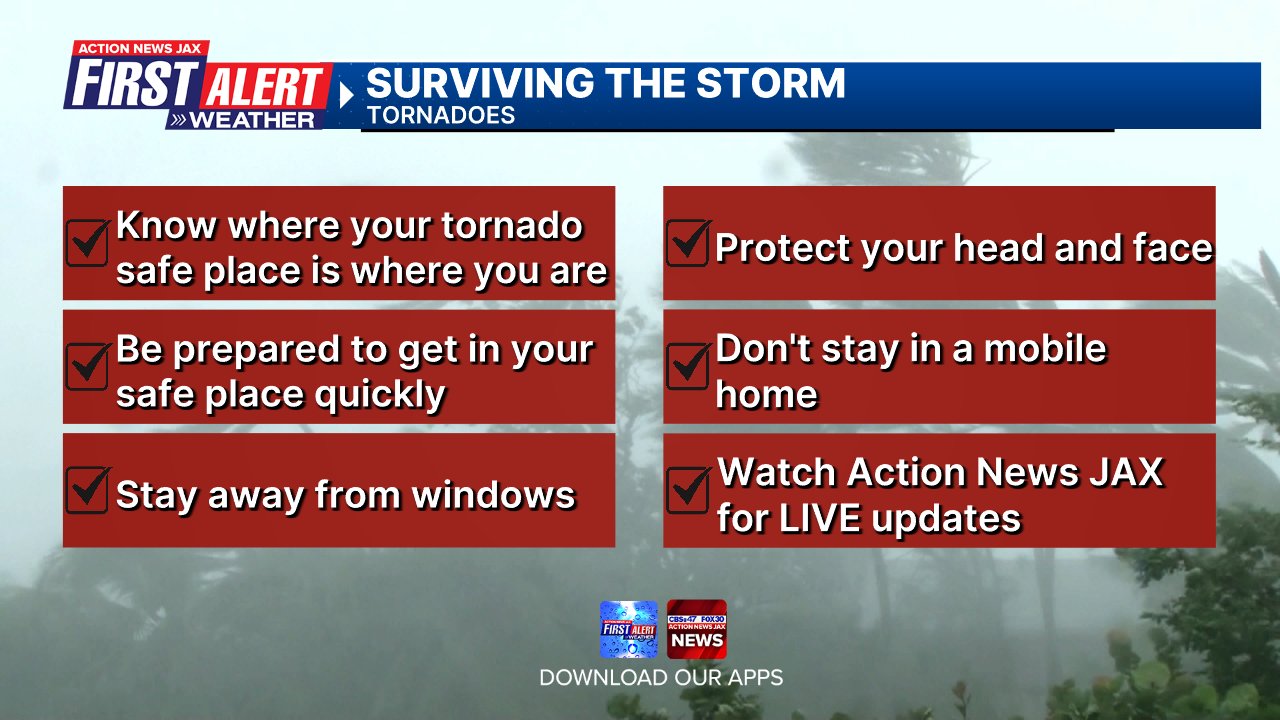
Tornadoes/waterspouts: Isolated threat Sunday afternoon increasing later Sunday night through Monday/Monday night.
Ocean: Seas will average 7-12 feet off the Ga. & Fl. coast, possibly higher by Tuesday depending on exactly where Debby is & how strong. Surf will build to 6-10+ feet. The onshore wind component will not be long lasting which is a good thing for the beaches.
Rip Currents: A high to very high rip current risk at area beaches. The best advice is to stay out of the ocean.
Storm Surge: Little. The majority of the flooding will be due to rainfall.
Power Outages: Sporadic for the I-95 corridor but more widespread & significant from Waycross, Ga. to Lake City, Fl.


The Atlantic Basin Overview:
A Storm Surge WARNING: Florida coast from the middle of Longboat Key northward to Indian Pass including Tampa Bay ... Georgia and South Carolina coast from the Mouth of the St. Mary’s River to South Santee River South Carolina.
A Storm Surge WATCH: Florida coast from Englewood northward to the middle of Longboat Key, including Charlotte Harbor.
A Hurricane WARNING: Florida coast from the Yankeetown to Indian Pass.
A Tropical Storm WARNING: Florida coast south of Yankeetown to Boca Grande ... Florida coast from west of Indian Pass to Mexico Beach ... Ponte Vedra Beach to South Santee River South Carolina.
(1) “Debby” - The 4th Atlantic named storm of the season continues to steadily move northward now over the Eastern Gulf within a moist atmosphere & now generally low shear not to mention very warm water. Convection has been pulsing & intense at times near the center of Debby & there have been occasional attempts at an eye wall.
Well - let’s give a tip of the hat to the GFS model - at least so far as - like with “Beryl” in late June/early July - the GFS has generally been superior. Now that Debby has moved over the very warm Southeast Gulf with lots of humidity in the air + less shear, the tropical cyclone is gradually becoming more organized with banding features & bursting of convection. Until a core can become established - which should be soon - the center may jump around some. Debby’s large, broad & spiraling circulation should eventually tighten & constrict some once strengthening begins in earnest only to spread out again after landfall. Mid & upper level shear will increase some upon approach to land but will be in the same direction as Debby’s forward movement which should be less detrimental to the tropical cyclone.
Debby will slow upon approach to Florida & there are indications of perhaps a very slow moving tropical cyclone after landfall as steering currents collapse. The result could be a storm capable of dumping 1-2+ FEET of rain along & east of the track with the highest severe flooding threat setting up along I-75 & I-10 in North Florida, much of Central & Southeast Ga... as well as the Carolina’s. 30″+ rainfall amounts are in play along an axis from landfall in the Big Bend to Lake City to Waycross through the eastern half of the Carolina’s.
The track has come down to - as expected - a potential alleyway between sprawling upper level high pressure cells - the Bermuda high & a summer-long second cell over the Southern/SW U.S. & an upper level trough digging southeast over the Eastern U.S. This will be in interesting & difficult to predict interaction as the upper level trough will add some upper level “ventilation” for Debbie adding to the potential for greater intensification. This interaction will also be key to whether or not Debby continues moving or gets left behind. Debby will be slow to weaken even over land due to likely intensification through landfall + a very favorable upper level environment courtesy the trough of low pressure. The “end game” is particularly perplexing - as to whether or not Debbie stays over land - Georgia &/or the Carolina’s or manages to get over the Atlantic offshore before moving either north or west again as upper level high pressure re-strengthens over the N. Atlantic & the trough lifts out & fills from the Eastern U.S. The European is the most east model & eventually takes Debby up the coast by mid to late week... while the GFS & Canadian models are much slower to do so & even at times indicate a turn back west.
It is important to realize & understand that while forecast models have come into much better agreement, there is still plenty of room for possibly significant forecast changes &, therefore impacts... especially if the incoming upper level trough fails to actually pick up Debby.
So *For the moment* Debby is expected to be at hurricane strength by landfall with a painfully slow move northeast & inland thereafter.
Keep in mind impacts from Debby will extend well away from the center...


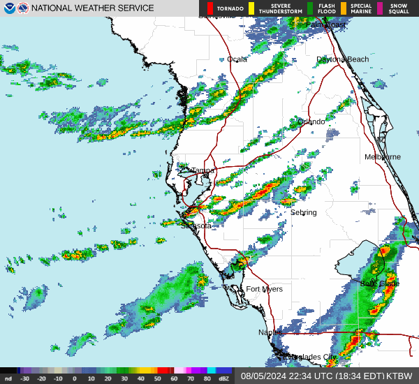
Radar imagery from S. Florida Water Management District:


500mb - about 30,000 feet - Sunday (08/04) showing the dipping trough - jet stream - between the two strong high pressure cells:


Composite map below shows water temps. (plenty warm - 85-90F+)... wind shear (decreasing markedly)... & dry air (not much):
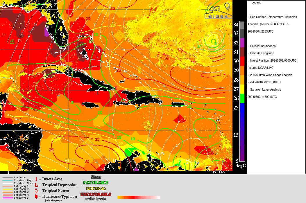
Wind shear dropping off dramatically over the Fl. Straits, Gulf:

(2) A couple of active tropical wave are over the Central & Eastern Atlantic. Forecast models are not too excited about the waves, but it’s something to watch as the African “wave train” starts to ramp up & the MJO pulse spreads eastward. One wave in particular will quickly cross the Caribbean over the next 5 days & has potential for especially long term development over the Western Caribbean &/or Western Gulf of Mexico.
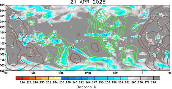
The velocity potential anomalies map below shows a lot of sinking air (brown lines) - & a lack of convection - over the Atlantic Basin to the far East Pacific while rising air (green lines) is over the Central & West Pacific more convection is notable. Often the green areas (MJO pulse) will correlate with increased tropical activity. So it’s the W. Pacific that will be more active now but this pulse should move eastward - signs of which we’re already seeing - helping to set off a return to a more active Atlantic through at least the middle of August.
REMEMBER WHEN A TROPICAL STORM OR HURRICANE IS APPROACHING: Taping windows is *not* recommended & will not keep glass from breaking. Instead close curtains & blinds.
Realize the forecast cone (”cone of uncertainty”) is the average forecast error over a given time - out to 5 days - & *does not* indicate the width of the storm &/or where damage might occur.

The upper oceanic heat content (UOHC) [tropical cyclone heat potential/TCHP] across the SW Atlantic, Gulf & Caribbean is unseasonably high for this time of year:


Water vapor loop (dark blue/yellow is dry mid & upper level air):


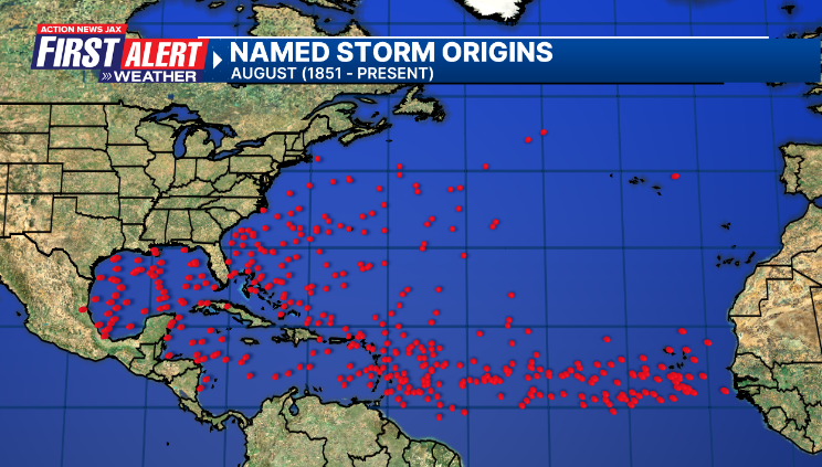
August tropical cyclone origins (early season breeding grounds are the Gulf &/or Western Caribbean:
Averages below based on climatology for the Atlantic Basin for August (1 hurricane so far, 3 tropical storms):

Wind shear (red - strong shear; green - low shear):


Saharan dust spreads west each year from Africa driven by the prevailing winds (from east to west over the Atlantic). Dry air = yellow/orange/red/pink. Widespread dust is indicative of dry air that *can* interfere with the development of tropical cyclones. However, sometimes “wanna’ be” waves will just wait until they get to the other side of - or away from - the dust plume then try to develop if other conditions are favorable. In my personal opinion, there is way too much “hoopla” about the presence of Saharan dust & how it relates to tropical cyclones. In any case, the peak of Saharan dust typically is in June & July.

2024 names..... “Ernesto” is the next name on the Atlantic list (names are picked at random by the World Meteorological Organization... repeat every 6 years). Historic storms are retired [Florence & Michael in ’18 (the last time this year’s list was used)... Dorian in ’19 & Laura, Eta & Iota in ‘20, Ida in ‘21 & Fiona & Ian in ‘22]). In fact, this year’s list of names is rather infamous because of the ‘04 season when Charley, Frances, Jeanne & Ivan - all retired names - hit Florida within a matter of about 6 weeks. The WMO decided - beginning in 2021 - that the Greek alphabet will be no longer used & instead there will be a supplemental list of names if the first list is exhausted (has only happened three times - 2005, 2020 & 2021). The naming of tropical cyclones began on a consistent basis in 1953. More on the history of naming tropical cyclones * here *.


East Atlantic:


Mid & upper level wind shear (enemy of tropical cyclones) analysis (CIMMS). The red lines indicate strong shear:

Water vapor imagery (dark blue indicates dry air):

Deep oceanic heat content over the Gulf, Caribbean & deep tropical Atlantic. The colors will brighten greatly as the water warms to greater depths deeper into the season:

Sea surface temp. anomalies:


SE U.S. surface map:

Surface analysis centered on the tropical Atlantic:

Surface analysis of the Gulf:

Caribbean:

Atlantic Basin wave period forecast for 24, 48, 72 & 96 hours respectively:


East & Central Pacific:
“Carlotta” has formed over the Eastern Pacific & has become the first hurricane of the season over the E. Pacific - one of the latest dates for such an occurrence on record. Nevertheless - no impact to land areas while moving west.
“Daniel” has joined Carlotta but is also no threat to any land areas followed by another developing tropical cyclone.


West Pacific:

Global tropical activity:


Cox Media Group


 Sign Up

