
Jacksonville, Fl. — The “Buresh Bottom Line”: Always be prepared!.....First Alert Hurricane Preparation Guide... City of Jacksonville Preparedness Guide... Georgia Hurricane Guide.
STAY INFORMED: Get the * FREE * First Alert Weather app
FREE NEWS UPDATES, ALERTS: Action News Jax app for Apple | For Android
WATCH “Preparing for the Storm”
WATCH “The Ins & Outs of Hurricane Season”
READ the First Alert Hurricane Center “Preparation Guide”
***** ALWAYS CHECK & RE-CHECK THE LATEST FORECAST & UPDATES! ****
Tropics threats for Jacksonville/NE Florida/SE Georgia: Increasing onshore flow during the upcoming week will result in an increasing rip current risk at area beaches.
The Atlantic Basin Overview:
(1) Multiple tropical waves are moving rather sluggishly to the west between the Caribbean & coast of Africa with the most active waves over the E. Atlantic. One of the lead waves is moving into the Caribbean & still has at least some long term potential but inconsistency amongst the forecast models remains large... huge actually. After a seemingly more consistent signal of at least a developing tropical cyclone emerged Thursday for a time, then again late Friday... just about each & every long range global model is seriously bouncing around on whether a tropical cyclone even develops ... to how strong ... to, of course, track. So there is not much to be definitive about at this point.
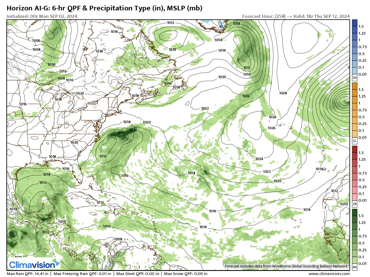
But - for right now - it appears the tropical wave over the Caribbean this week will continue westward nearing the Yucatan Peninsula by the weekend. A new model the First Alert weather team has access to is the ClimaVision “Horizon” model which shows the tropical cyclone moving over the SW Gulf in 7-10 days. While the location has certainly varied, the model at least has consistently shown a tropical cyclone developing (vs. storms appearing then disappearing as is the case with many of the traditional global models right now).
A slower to develop system (more shallow) would like get farther west which is where virtually all the models have now trended.
(2) We’re also seeing mixed signals regarding a nearly stationary boundary from the Gulf to the Western Atlantic that gets reinforced by a series of upper level troughs & possible low pressure developing at the surface along the front. This could be some “in-close” development anywhere from the Gulf to the far Western Atlantic. T’storms continue persistent near the Texas coast, but proximity to land will likely limit much tropical development. And some models indicate the potential for some tropical activity from near the Florida (Eastern Gulf) northeast coast northward across the Western Atlantic - as soon as mid to late week. But - again - not a lot to hang one’s hat on for right now.
Fitting the pattern for an increase in tropical activity is persistent & seasonally strong surface high pressure at northern latitudes from the Central U.S. to the Northwest Atlantic. This high pressure will bring an early taste of fall across the Northern U.S. & may induce general low pressure to the south - a pattern that *could* favor tropical development at southern latitudes.


The experimental Climavision ‘Horizon’ model below for Thu., Sept. 12th has trended much more south & southwest vs. the past week. While jumping around on position, the ‘Horizon’ has at least consistently shown development but has delayed when that development might occur.
Very heavy rain for much of the Gulf coast this week:


‘Velocity potential anomalies’ below shows massive “sinking” air (brown lines) & overall hostile conditions for tropical development continue across the Atlantic Basin. In such a state, tropical development can occur but overall conditions are not as conducive as when there is overall rising (green lines) air such as much of the Pacific Basin where convection is active. This “pulse” of upward motion should move over the Atlantic Basin over the next few weeks.

REMEMBER WHEN A TROPICAL STORM OR HURRICANE IS APPROACHING: Taping windows is *not* recommended & will not keep glass from breaking. Instead close curtains & blinds.
Realize the forecast cone (”cone of uncertainty”) is the average forecast error over a given time - out to 5 days - & *does not* indicate the width of the storm &/or where damage might occur.

The upper oceanic heat content (UOHC) [tropical cyclone heat potential/TCHP] across the SW Atlantic, Gulf & Caribbean is unseasonably high for this time of year:


Water vapor loop (dark blue/yellow is dry mid & upper level air):


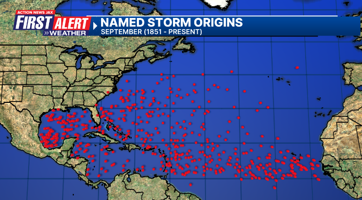
September tropical cyclone origins (early season breeding grounds are the Gulf &/or Western Caribbean:
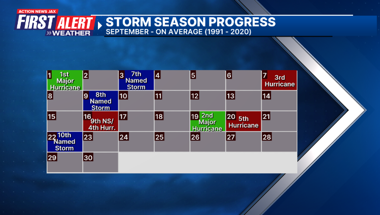
Averages below based on climatology for the Atlantic Basin for September (2 hurricane so far, 3 tropical storms):
Wind shear (red - strong shear; green - low shear):


Saharan dust spreads west each year from Africa driven by the prevailing winds (from east to west over the Atlantic). Dry air = yellow/orange/red/pink. Widespread dust is indicative of dry air that *can* interfere with the development of tropical cyclones. However, sometimes “wanna’ be” waves will just wait until they get to the other side of - or away from - the dust plume then try to develop if other conditions are favorable (we’ve already seen this with Beryl & Debby this year). In my personal opinion, there is way too much “hoopla” about the presence of Saharan dust & how it relates to tropical cyclones. In any case, the peak of Saharan dust typically is in June & July.

2024 names..... “Francine” is the next name on the Atlantic list (names are picked at random by the World Meteorological Organization... repeat every 6 years). Historic storms are retired [Florence & Michael in ’18 (the last time this year’s list was used)... Dorian in ’19 & Laura, Eta & Iota in ‘20, Ida in ‘21 & Fiona & Ian in ‘22]). In fact, this year’s list of names is rather infamous because of the ‘04 season when Charley, Frances, Jeanne & Ivan - all retired names - hit Florida within a matter of about 6 weeks. The WMO decided - beginning in 2021 - that the Greek alphabet will be no longer used & instead there will be a supplemental list of names if the first list is exhausted (has only happened three times - 2005, 2020 & 2021). The naming of tropical cyclones began on a consistent basis in 1953. More on the history of naming tropical cyclones * here *.


East Atlantic:


Mid & upper level wind shear (enemy of tropical cyclones) analysis (CIMMS). The red lines indicate strong shear:

Water vapor imagery (dark blue indicates dry air):

Deep oceanic heat content over the Gulf, Caribbean & deep tropical Atlantic. The colors will brighten greatly as the water warms to greater depths deeper into the season:

Sea surface temp. anomalies:


SE U.S. surface map:

Surface analysis centered on the tropical Atlantic:

Surface analysis of the Gulf:

Caribbean:

Atlantic Basin wave period forecast for 24, 48, 72 & 96 hours respectively:


East & Central Pacific:
“Hone” has become post-tropical:


Hawaii satellite imagery:


West Pacific:

Global tropical activity:


“Yagi” is expected to intensify as it leaves the Philippines & turns westward toward China:


Cox Media Group


 Sign Up

